 |
| These are actually porters taking goods across the border. Several semi sized trucks are parked about a kilometer from the border and are unloaded into these carts. Potatoes and tomatoes going one way and bricks going the other. |
 After another 12 hour bus ride, I am Cuzco. I really do like the buses here in South America, they are comfortable, inexpensive and sometimes, like this one, take a lot of hassle out of the trip. For 180 Bolivars (roughly $25) I got lunch and a direct trip in comfort from LaPaz to Cusco, and the bus even waited at the border for everyone to clear immigration!
This time it was a daytime ride, and I managed to get a second floor, front seat which can be very warm in the sunshine but definitely worth it for the view. At the border crossing into Peru we had a rather long 1.5 hour wait in line (on the street) for immigration, but it was a nice warm day so it wasn't so bad. I thought it was warm in the shade and hot in the sun, but I noticed most of the locals were dressed in coats and sweaters. I didn't think much of it at the time, but a few kilometers down the road as we were driving by Lake Titicaca, I was rather shocked to see snow on the ground. I guess we aren't the only ones to get snow in summer!
 |
| Lake Titicaca |
Lake Titicaca is a bit different than I expected - for some reason I had it in my mind it was in the mountains, but in actuality tha aera around is quite flat with some large hills. It is definitely a large lake, however, as we were driving along its shores for a good three hours.

Some interesting sights along the way: Three road workers were digging a hole in a section of road a few kilometers from the nearest town. Their equipment included a pick-axe and a few shovels, 2 safety pylons and 3 bicycles. At another major roadworks, a welder was working on some metalwork and his portable rig consisted of a bicycle rigged to carry a full-size acetylene tank and torch. Motorcycle trucks and bicycle wagons everywhere. And finally, Perurail seems to run their trains consisting of one engine and only about 5 cars, either passenger or cargo, empty or full.
 |
| Baby llamas and traditional outfits |
After passing through Puno and leaving Lake Titicaca, we once again entered the mountains, only this time they were very familiar; they were made of granite and there was a tree line in addition to the snow line.
 |
| Plaza de Aramanis |
 |
| More llamas, but not nearly as cute as the little dragon ones, though perhaps that isn't important if they are just getting put under the floor. |
 Oddly enough, I don't
find Cusco to be as ' touristy' as I thought it would be. It is of course quite touristy in places, but on the whole is just a regular town. The one tourist thing I found a little annoying was that all the churches are closed or you have to pay a fee to visit and all the museums have a fee. And to make it a tad more annoying is there isn't a small individual fee, it is a large bundle fee which includes a lot of out-of-town sites, meaning time and advance planing are required in order to take advantage. (To be fair, the bundle fee is actually quite reasonable if you can plan ahead for the various sites).
Oddly enough, I don't
find Cusco to be as ' touristy' as I thought it would be. It is of course quite touristy in places, but on the whole is just a regular town. The one tourist thing I found a little annoying was that all the churches are closed or you have to pay a fee to visit and all the museums have a fee. And to make it a tad more annoying is there isn't a small individual fee, it is a large bundle fee which includes a lot of out-of-town sites, meaning time and advance planing are required in order to take advantage. (To be fair, the bundle fee is actually quite reasonable if you can plan ahead for the various sites).
 It
certainly isn't hard to find a church in the old part of town, like old Spanish cities, all you have to do is walk a block or two.
It
certainly isn't hard to find a church in the old part of town, like old Spanish cities, all you have to do is walk a block or two. |
| Inca retaining walls with the church built on top |
 |
| Saint Dominic sitting atop the original retaining walls of Qorikancha |
 |
| Incan stonework |
 |
| Interior of Saint Dominic church - if you look carefully, you can see part of one of the original Inca temples behind the arches. |
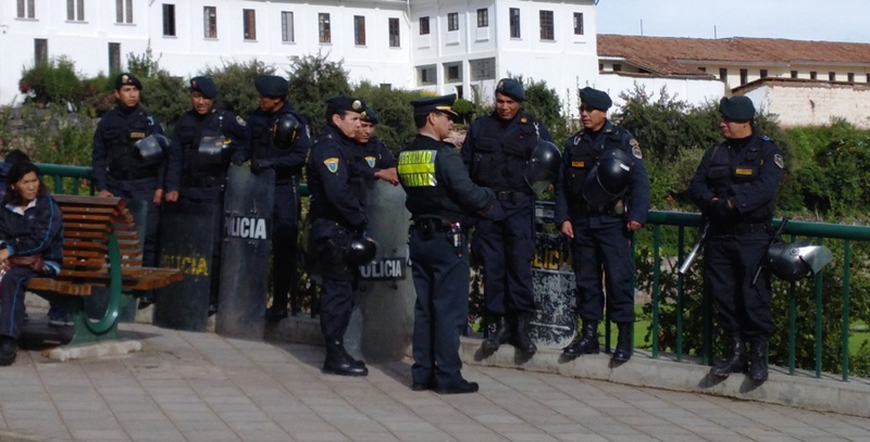 |
| Public transit was on strike for a day and so the police were ready for something, but nothing happened |
 On this elevated area were buildings and several
temples and it was these buildings that were plundered and
destroyed. The flat area was a perfect foundation for the Spanish to
built their church incorporating
some of the remaining Incan temple walls as rooms in the church.
On this elevated area were buildings and several
temples and it was these buildings that were plundered and
destroyed. The flat area was a perfect foundation for the Spanish to
built their church incorporating
some of the remaining Incan temple walls as rooms in the church.--Section; 645km -Trip total; 26210km
friday, march 8, 2013
Ollantaytambo
 |
| In the rural areas there is a lot more of the traditional dress in common use |
 |
| My hotel |
I arrived in Ollantaytambo and lucked out in getting a great hotel for a good price ($14) and it was before noon, so I had plenty of time to visit the nearby Inca ruins.

 This town was the sight of an Inca settlement that was never defeated by the Spanish. The Inca ruins that most people come to see are the expected hillside walls, terraces and houses. In order to see Inca ruins up close, it is not necessary to climb the hills, as much of the town of Ollantaytambo is actually built on the foundations of
the original Inca townsite .
This town was the sight of an Inca settlement that was never defeated by the Spanish. The Inca ruins that most people come to see are the expected hillside walls, terraces and houses. In order to see Inca ruins up close, it is not necessary to climb the hills, as much of the town of Ollantaytambo is actually built on the foundations of
the original Inca townsite . |
| These ancient streets are better than most rural towns build today |
 |
| Pay-to-see ruins |
 |
| Free ruins |
 |
| there were even water features |
The largest is now a protected archeological site and there is a fee to visit, while on the other side of the valley there are some buildings that are free to visit.
 |
| This appeared to be a temple area and these rocks stood significantly taller than me...and not a millimeter crack between them |
The larger is obviously awe inspiring due to the sheer size and content, while the smaller is captivating due to the location and intactness of some of the buildings as well as the vistas it provides of the town and larger site.
Both sets of ruins are in amazingly good condition, with walls intact and houses just missing roofs.
--Section; 78km -Trip total; 26288km
saturday, march 9, 2013
Agua Caliente
 |
| bonus - only 6 passengers |
 Today I take the famous train ride from Ollantaytambo to Agua
Caliente, which sits in the valley below Machu Picchu. This town was
originally known as Machu Picchu, but the name was changed to avoid
confusion with the archaeological sight and comes from the natural hot
springs that are present.
Today I take the famous train ride from Ollantaytambo to Agua
Caliente, which sits in the valley below Machu Picchu. This town was
originally known as Machu Picchu, but the name was changed to avoid
confusion with the archaeological sight and comes from the natural hot
springs that are present. |
| Complimentary snack - two 5cm buns and a 1/2 glass juice (and this is the 'better' snack) |
 The train ride itself was a bit disappointing in that the views were
not as good as I had come to expect. There is plenty of scenery
available, but unfortunately the seats in the train are set in such a
way that most have a 20cm post right in the way of the passengers view. The two
seats with a good view are 1 and 2 (but only in the first carriage).
Because of schedules available, I ended up taking the expensive train both directions and for the supposed upgrades (seats, snacks etc) that the
30% premium is supposed to buy, I don't think I could recommend it, with
the exception that if you are lucky enough, as I was, to have an empty
carriage and you can wander and pick any seat you wish, then it is worth
the extra.
The train ride itself was a bit disappointing in that the views were
not as good as I had come to expect. There is plenty of scenery
available, but unfortunately the seats in the train are set in such a
way that most have a 20cm post right in the way of the passengers view. The two
seats with a good view are 1 and 2 (but only in the first carriage).
Because of schedules available, I ended up taking the expensive train both directions and for the supposed upgrades (seats, snacks etc) that the
30% premium is supposed to buy, I don't think I could recommend it, with
the exception that if you are lucky enough, as I was, to have an empty
carriage and you can wander and pick any seat you wish, then it is worth
the extra. 
 After arriving and finding a quiet, inexpensive hotel, I had a wander about the town. Augas Caliente is a bit of a grubby little overpriced tourist
town, but if spite of that I liked it. Pehaps it is the mountains that
rise vertically all around, or the two rivers that roar through town,
but there is something about it that is captivating. The major river has
such a large volume of water crashing through truck sized boulders, it
sounds like a waterfall and nearly drowns out all other noise in town.
After arriving and finding a quiet, inexpensive hotel, I had a wander about the town. Augas Caliente is a bit of a grubby little overpriced tourist
town, but if spite of that I liked it. Pehaps it is the mountains that
rise vertically all around, or the two rivers that roar through town,
but there is something about it that is captivating. The major river has
such a large volume of water crashing through truck sized boulders, it
sounds like a waterfall and nearly drowns out all other noise in town. |
| One river cuts through the middle of town so a set of pedestrian bridges join the two sides. Cars are non-existent and all the streets are pedestrian lanes. |

--Section; 50km -Trip total; 26344km
sunday, march 10, 2013
Machu Picchu
 I got up this morning at 4am to the sound of rain. Realizing there
would be no sunrise today, I took my time packing and was walking
shortly after 5am. The first 1.5 kilometers walking downhill along the
road was uneventful other than avoiding the buses taking employees up
the hill. Arriving at the bridge across the river you have to show your
ticket and identification. Immediately after crossing the bridge, take
the small side road to the right marked for the museum/ gardens (no
mention of Machu Picchu). Fifty meters up, on the left side, the trail
starts, or rather the stairs start. Over the next 2.5 km you climb
450 meters to get to the park entrance.
I got up this morning at 4am to the sound of rain. Realizing there
would be no sunrise today, I took my time packing and was walking
shortly after 5am. The first 1.5 kilometers walking downhill along the
road was uneventful other than avoiding the buses taking employees up
the hill. Arriving at the bridge across the river you have to show your
ticket and identification. Immediately after crossing the bridge, take
the small side road to the right marked for the museum/ gardens (no
mention of Machu Picchu). Fifty meters up, on the left side, the trail
starts, or rather the stairs start. Over the next 2.5 km you climb
450 meters to get to the park entrance.
 I arrived at 6:20. It was still
raining. Although I wore rain gear, it was mainly to keep the rain off
my pack, as I was soaked with sweat anyway, so I changed into dry
clothes and continued up.
I arrived at 6:20. It was still
raining. Although I wore rain gear, it was mainly to keep the rain off
my pack, as I was soaked with sweat anyway, so I changed into dry
clothes and continued up. |
| Waiting for the sun at the Sun Gate |
 My theory was I would catch the second sunrise
at the Sun Gate which is another 1.4km further up the Inca Trail. This time the
elevation gain is only 220 meters, but it looks down on Wayna Picchu
(the tooth-like mountain that is in the background of all Machu Picchu
pictures). Part way up I realize it has stopped raining.
My theory was I would catch the second sunrise
at the Sun Gate which is another 1.4km further up the Inca Trail. This time the
elevation gain is only 220 meters, but it looks down on Wayna Picchu
(the tooth-like mountain that is in the background of all Machu Picchu
pictures). Part way up I realize it has stopped raining. Shortly after I
arrive at IntiPunku (the Sun Gate) the clouds break up somewhat and
Machu Picchu and some of the surroundings are visible, so I quickly snap
a few pictures. Then the sun starts to work it's magic and the mists
start to form, so for the next hour, nothing is visible.
Shortly after I
arrive at IntiPunku (the Sun Gate) the clouds break up somewhat and
Machu Picchu and some of the surroundings are visible, so I quickly snap
a few pictures. Then the sun starts to work it's magic and the mists
start to form, so for the next hour, nothing is visible.
Suddenly the sun breaks through, the mists disappear and it is instantly hot for the rest of the day.
 |
| section of Inca Trail |


 Machu Picchu is amazing, but because the real thing is exactly like the pictures, I
kept having the feeling I had stepped into one of Mary Poppins chalk
drawings. Not everything was deja-vous however, as there were a few
unexpected surprises, such as the Condor and being able to walk through
its belly.
Machu Picchu is amazing, but because the real thing is exactly like the pictures, I
kept having the feeling I had stepped into one of Mary Poppins chalk
drawings. Not everything was deja-vous however, as there were a few
unexpected surprises, such as the Condor and being able to walk through
its belly. |
| Condor Temple |


After several hours of wandering, it was time to head down. for a well deserved drink, dinner, catch the train and then colectivo back to Cusco.
--Section; 138km -Trip total; 26482km
tuesday, march 12, 2013
Nazca-Ica-Huacachina
 Today is going to be a long one, as I have a lot of ground to cover
and things to do! First, the night bus to Nazca, which is the easy part.
Then, find a place to stow my gear for the day and get to the airport
to buy a flight over the Nazca lines and figures. Then catch a colectivo
to Ica and finally a taxi to Huacachina. ....at least, that is the
plan.
Today is going to be a long one, as I have a lot of ground to cover
and things to do! First, the night bus to Nazca, which is the easy part.
Then, find a place to stow my gear for the day and get to the airport
to buy a flight over the Nazca lines and figures. Then catch a colectivo
to Ica and finally a taxi to Huacachina. ....at least, that is the
plan. |
| Green by the river - rocks and sand everywhere else! |
Wow, the plan worked out without any real hitches! I probably paid too much for the flight in Nazca, but I figured I didn't have a lot of time to muck about, so I rationalized the extra was for convenience (and I did get the use and security of a hotel room for the day, which was nice). I wonder if the trip through the mountains from Cusco to Nazca would be interesting enough to do as a daytime ride? I do know I woke up a few times wondering what kind of roller coaster we were on, as we wound our way slowly up and then down and then back up and back down and ...and... for 14 hours.
 |
| the Atacama Desert in Peru looks a lot like the Atacama Desert in Chile |
 |
| the 'Hummingbird' |
 |
| the 'Astronaut' |
 |
| Courtyard - my $7 hostel |
 I left Nazca by noon and was in Ica a couple of hours later. Two
hours of nothing but sand and gravel and rocks and in the distance
mountains made of sand and gravel and rocks. Welcome once again to the
Atacama! I didn't spend any time in Ica, but caught a taxi right away to
Huacachina, which is only a couple of kilometers out of town. This is
pretty much a village of hotels, hostels restaurants on the one street
built around an oasis in between some of the largest sand hills I've
seen. The two attractions here are dune buggy tours and sand-boarding. I
had pretty much checked out all the places to stay, selected one and
then checked out the town by 3:30, so it was time to do some
sand-boarding!
I left Nazca by noon and was in Ica a couple of hours later. Two
hours of nothing but sand and gravel and rocks and in the distance
mountains made of sand and gravel and rocks. Welcome once again to the
Atacama! I didn't spend any time in Ica, but caught a taxi right away to
Huacachina, which is only a couple of kilometers out of town. This is
pretty much a village of hotels, hostels restaurants on the one street
built around an oasis in between some of the largest sand hills I've
seen. The two attractions here are dune buggy tours and sand-boarding. I
had pretty much checked out all the places to stay, selected one and
then checked out the town by 3:30, so it was time to do some
sand-boarding! |
| Huacachina sandboarding |
--Section; 837km -Trip total; 27319km
friday, march 15, 2013
Paracas

 I joked about being on the beach in Ica, but the reality is that I was. The sand hills became smaller but the sand is continuous all
the way to the coast. Occasionally crops and a few vineyards and orchards have been planted which break up the scenery,
but this beach is essentially 65 kms wide.
I joked about being on the beach in Ica, but the reality is that I was. The sand hills became smaller but the sand is continuous all
the way to the coast. Occasionally crops and a few vineyards and orchards have been planted which break up the scenery,
but this beach is essentially 65 kms wide.


Paracas is a small town on the coast with two streets and not a lot going on, but at 8 am every morning hundreds of tourists show up and form long queues on the dock. They are there to and catch one of the speedboat tours that will wisk them out to the Islas Ballestas National Reserve which has been called the Galapagos of Peru.

 |
| The 'Candelabra' can be seen on the way out to the Ballestas |

 The Ballestas Reserve isn't really a Galapagos, but the reserve, which is a group of rocky
islands, is home to thousands of birds of a dozen or more
species as well as sea lions. There are
even penguins. The islands themselves are rather interesting as
the ocean has carved
many holes and caves in and through their bases.
The Ballestas Reserve isn't really a Galapagos, but the reserve, which is a group of rocky
islands, is home to thousands of birds of a dozen or more
species as well as sea lions. There are
even penguins. The islands themselves are rather interesting as
the ocean has carved
many holes and caves in and through their bases.

It isn't necessary, however, to go to the islands to see many birds, as it is easy
to spot a half dozen species on the beach in town while you watch the pelicans fishing.
 |
| map |
--Section; 132km -Trip total; 27451km
tuesday, march 19, 2013
Lima
A quick four hour trip to Lima this afternoon for an overnight and then home(ish) in the morning
The trip to Lima was more desert... or beach if you prefer... I thought it very innovative where people had built their shacks and to get running water had placed a water container several meters up the sand dune behind their shack .Approaching Lima, at about a hundred kilometers out the air starts to get very thick and brownish, and the closer in you get the the more crowded and congested it gets with both people and vehicles. It is dirty and expensive (possibly the least value per $ location in SA that I've been to). I didn't much care for Lima. One the positive side, all that smog made for a really nice sunset though.
Lima does not have a central bus terminal, which I did not know at the time, and so I found myself at the bus company terminal in a sort of industrial part of town about five kilometers further away from the center than I had anticipated. It was dark. The taxis were charging about three times what I considered to be reasonable and it isn't wise to hail a taxi off the street in Lima. Besides, there weren't any taxis to be hailed on the street as far as I could see. I ended up paying slightly less than a ridiculously expensive fare. It took nearly an hour to go 20km but I eventually found myself at my hostel. The hostel reviewed a lot better than it appeared in person and it made my hotel in Paracas, which was slightly cheaper, look like the Hilton. I told myself it was only one night and went to bed.
In the morning it was off to the airport where the two and a half hours leeway I gave myself was only barely enough to make it through the massive waits at ticketing, security and immigration before arriving at my gate with 15 minutes to spare. On one hand I was sad to be leaving, but on the other I was excited to be heading towards home.
--Section; 273km -Trip total; 27592km
Before I could click my heels three times, I'm freezing my buns off in Toronto (at -3C) walking down the street looking for the bus station.
--Section; 6521km -Trip total; 34113km